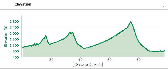
Distance:98.0 miles (157.7 kms)
Total time: 10hrs10mins (including stops for chats with Harley riders and others, a puncture, lunch and a much needed refueling stop later in the day)
Average Moving Speed: 14.6mph (23.5 kph)
Maximum Speed:42.9mph (69.0kph)
Calories burned: 5015
Powered by: 3 egg omelette/fried potatoes/whole wheat toast for breakfast, 2 protein bars, 2 bananas, about 3 liters of water, 2 liters of Gatorade, 1 liter of iced tea, 1 Coke, 1 Mississippi Mud Pie fudge ice cream sandwich, a handful of salt and vinegar chips (crisps) and 1 GU gel.
Weather: Very sunny with light N wind, but it seemed to be a head wind for a large part of the day; temperatures rose from 64F (18C) to 90F (33C).
I knew that this would be a long day but I did not expect it to be as long as it turned out. The day started well with a large 3 egg omelette complemented by potatoes and toast at Bacon and Eggs in Walla Walla. I had to wait to 8am till they opened but it was worth the wait. I finally pushed off at 9:30am on the Lewis and Clark trail across the Palouse.
The route out of Walla Walla was empty, the day was cool, the surface was great, and the wheat fields all round looked ready for harvesting. I remembered a paper published in the ANNALS, ASSOCIATION OF AMERICAN GEOGRAPHERS in 1960 by Peirce Lewis of Penn State geography on the physical geography of the region. I'll have to go back to read it after my traverse of the region. It was a lot drier and hillier than I expected with many grades in the 5-6% range till I got to Waitsburg. The huge expanses of wheat at their yellowish best certainly provoked images of 'amber waves of grain', though the wind was light at this point and the wheat was not moving.
I stopped in Waitsburg to oil the chain as it was squeaking a bit and made good time to Dayton where I had a lunch of bananas, protein bars and Gatorade. Two young missionaries tried to convert me as I sat in the park shelter but that was a waste of their time; I'll give them points for chutzpah anyway.
A few miles out of Dayton on the way to Pomeroy, on one of the many inclines, I got that familiar (literal) sinking feeling as the rear tire lost air. I remembered going through shattered glass on the shoulder (margin) near town which might have been the cause. By now, the temperature was in the mid 80s (30C) and not a sign of shade so no option except to change the tube on the roadside. I could not pump up the first replacement tube - I think I took a dud one from the bike box in our garage. The second tire seemed ok and I was especially careful to check inside the tire for any bits of wire or anything that might puncture the replacement. But I could not get the tube inflated with the small pump that I had. An elderly woman stopped and asked if I needed help but before I could answer, a van with bikes on top had also stopped. Nick and Heather and family from Portland had seen me in the ditch as they headed west and they turned around to offer assistance. They had a nifty small pump (LeZyne) and it did the trick. They also topped up my water and I'm very grateful for their help. As Heather said, there is bicycle karma and she expects to benefit from some stranger's help at some point in the future.
I rode cautiously at first but gained confidence that the tube would hold as the miles passed. It was now a gradual climb to Pomeroy, about 25 miles. I stopped at a rest area to drink and stayed almost an hour talking to Harley riders who pulled in and other travelers who were curious about my journey, equipment, training (hah!), and schedule. By the time I got to Pomeroy, it was almost 5:30pm and I was running out of water and Gatorade, and needed a boost. A visit to the grocery store procured Coke, water, raspberry iced tea, crips (crisps) as I craved salt, and a large Mississippi mud pie which was a gooey fudge chocolate ice cream sandwich. This haul was enough to power me over the Alpowa summit about 2600 ft and allow a long 5-6 mile jaunt down the incline, where I hit speeds over 40mph (65kph). The runaway truck ramp had been used recently and I would guess that the grade was a good 5-6% all the way.
From the end of the speedy descent, it was still 15 miles to Lewiston into a head wind in the Snake river canyon. Nothing for it but to put the head down and pedal on a rough shoulder (margin). I finally crossed the river into Idaho about 7:30pm, a 10 hour day, as the sun was going behind the canyon walls. Happily, there was a brew pub beside the hotel and two pints of their best pale ale, salad, and two entrees rewarded my efforts for the day.Though I could have gone another 25-30 miles - or at least, my legs could - it was a good time and place to stop for the day.

Tomorrow I head towards the start of the climb to Lolo Pass and onto Montana. it should be a shorter day, at least.


No comments:
Post a Comment