Distance:44.5 miles (71.6 kms)
Total time: 5hrs13mins (including lunch stop)
Average Moving Speed: 11.0mph (17.7 kph)
Maximum Speed:37.3mph (60.0 kph)
Calories burned: 2874
Elevation gained: 5295ft (1614 meters)
Elevation gained: 5295ft (1614 meters)
Weather: Light rain at 8am in the morning but the sun was coming out when I left around 10:30am. Temperatures rose much to 80degF (27C) in Frostburg and the weather was good for biking. While hot on the uphills, the temperature was cool enough that the fast downhills were refreshing. Winds were very light from the northwest all day.
Powered by: Breakfast - 2 boiled eggs, bowl of Raisin Bran, bagel, yogurt, fruit and a banana. Lunch of salad and potato salad, a fewhealthy whole wheat Fig Newtons (Fig Rolls),1 liter of Gatorade, 1 banana and 2 liters of water.

My plan to stay overnight in Cumberland was undermined by the full hotels in the area on a summer weekend as the town attracts a lot of tourists. So I booked in Frostburg, about 10 miles away. I had the option of going farther north to catch the Great Allegheny Passage, a bike trail along an abandoned railroad bed from Pittsburgh to Cumberland where it connects to the C&O canal path to Washington DC. So one could ride with traffic worries for over 300 miles and miss the big climbs over the ridges. At a couple of points today, I felt like kicking myself for not taking the detour to the trail as I had opted to take the shortest route to Frostburg along the historic National Road, US 40. This road is now mostly two-lane with a wide shoulder (margin) as Interstate 68, which parallels it a short distance away, has taken most of the long-distance traffic. On a Saturday, there was even less traffic and the ride was pleasant, if tough.
As the elevation profile shows, US40 goes up and down the Allegheny ridges. Historically, these ridges running NE to SW posed quite a barrier to travel and settlement to the West. The first 'road', the National Turnpike with tolls, was completed to Wheeling in the 1830s and the early automobile route was completed in the 1910s. Compared to the Rockies, the elevations are not high (highest points are around 3000 feet) but the grades are steep and the ridges seem incessant, especially on a loaded bike. A climb is typically between 0.5 and one mile at a grade not less than 6% and usually at 8-11%. Then the fast downhill and repeat.
After early morning rain, the sun came out and the humidity of the past few days started dropping noticeably. The high temperature was in the 70s all day which would be pleasant under normal circumstances but it still produced a very sweaty climb followed by chilly descent as the sensation is like getting out of a hot shower into a cold room. No wonder riders in the Tour de France grab newspapers from spectators at the summits of climbs to stick into their jerseys as they descend. After yesterday's 8000 feet of cumulative climbing over 91 miles, my legs did not have their usual zip and I had to take the climbs slow and steady rather than attacking them as fast as I could make it uphill. It's probably a good thing that today's ride was unexpectedly short as it gives the legs a chance to recover before the next cluster of ridges.
Summer fun on the Yoghiogheny river, which is dammed at this point
Old Route 40 has a nice shoulder and passes through interesting country, both historical and physical
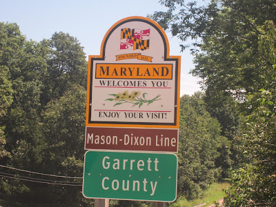
Today's route took me from West Virginia to Pennsylvania for a while and then across the most famous boundary in American history, the Mason-Dixon line, into Maryland. The road is littered with historical markers, especially of (British) General Braddock's march in 1755 towards what is now south-western Pennsylvania in his entanglements with the indigenes. Each ridge's summit is marked with its height and some have historical plaques with old pictures of what the road used to look like over a century ago.
It looked like it still might be open and the price looks like it has not been changed since the 1970s.
A good historical plaque about the Mason-Dixon line and the building of the national road, route 40
An account of Mason and Dixon whose famous line is best known to American schoolchildren as the divide between slave and free states before the Civil War
My 15th and second last state
Another ridge to climb coming up ahead
The highest point on the road with an anachronistic name. Named after an early settler.
It's not all downhill from here - many more ridges ahead
Another ridge conquered; most of the grades are 8-11%
Does it apply to bikes too? How could you ditch your bike if the brakes failed?
I finished much earlier than is my normal arrival and look forward to an easier day tomorrow to Hancock MD along the C&O canal path. Since it's a dirt trail, I hope that the recent heavy rain has not turned it to a muddy goo that makes riding impossible. If so, it's back to US 40 and the ridges.
Today I passed 3000 miles since the Oregon coast and with about 350 miles remaining, I am almost 9/10ths of the way to my destination. I hope to finish on Thursday next, assuming no hiccups.


No comments:
Post a Comment